 THE ROUTE: Drive from Denali National Park Visitor Center to Teklanika Campground. Travel is east to west (right to left on the above map).
DISTANCE: ~29 miles.
TERRAIN: Pavement to Savage River Ranger Station, the remainder is gravel to Teklanika Campground.
 DAY ONE: We arrived at Teklanika Campground on a very warm and sunny afternoon. We sat up our camp and began enjoying the weather and our surroundings.
 About two hours after we arrived a sow and cub grizzly showed up and began digging for pea vine roots about 40 yards from our camp.
 This is a picture of the sow as she searched for roots.
 I am just beyond the door of our camper. The bears also look very close due to the effect of the camera lens.
 Posing for the camera.
 After the bears left I walked out to see what they had been digging for. They left a great number of these holes in the river bed in their search for roots.
 We also attended a ranger presentation on our first evening at Teklanika Campground. This is Ranger Dan. He told us all about lynx and wolves. He is holding a lynx pelt in this photo.
 Emily was working on her Junior Ranger booklet so she had Ranger Dan sign it for her at the end of his talk.
 We took a walk around the campground at the end of our first day and saw this sunset. It was quite beautiful and a great way to end a very eventful first day at Teklanika Campground.
 The next morning I woke up at 4:00 AM and walked down to a mound where I took this photo of the Teklanika River. It's a clear example of a 'braided river."
DAY TWO: On our second day in the park we decided to take a hike on Polychrome Pass. We loaded our packs with food, water, and gear. Then we caught a bus to the Polychrome Rest Area.
 THE ROUTE: We got off the bus at the Polychrome Pass rest area and walked back down the road to a spot where we followed a social trail upward toward some ridges above Polychrome Pass. We walked along the ridges, down into a canyon and back to the Polychrome rest area.
TERRAIN: Steep hiking on crumbly gravel surfaces up to the ridges. Once on the ridges the hiking is easy on compacted dirt. The views are terrific as you can see a great distance in many directions.
 Mrs. Huffy ascends toward a ridge above Polychrome Pass. The park road is below her.
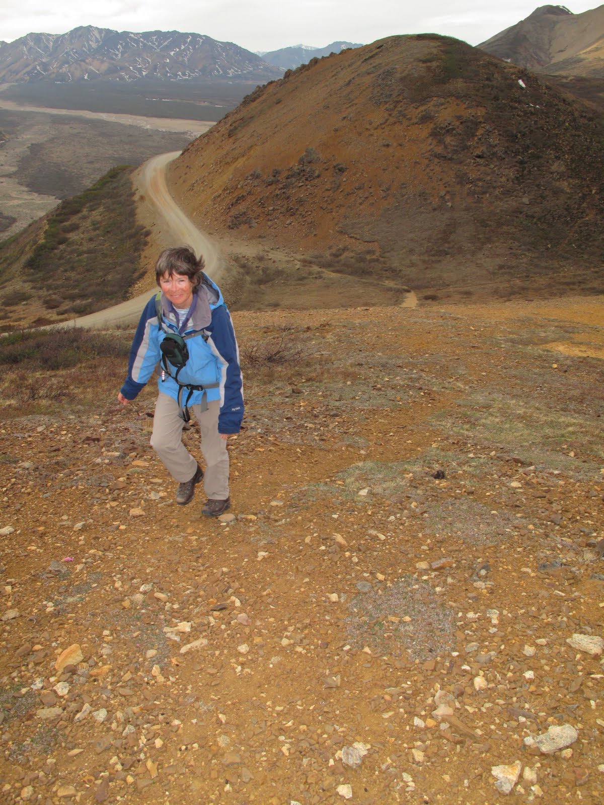 Mrs. Huffy gets closer to the top of the ridge where the hiking becomes much easier.
 The Hufford girls stop for a photo on one of the high ridges above Polychrome Pass.
 Laura and Mrs. Huffy with Polychrome Basin far below them in the background.
 The view out the front of the bus window on our ride back to Teklanika Campground. Notice the drop on the right hand side of the road. It's quite spectacular to ride over Polychrome Pass.
 When we got back to camp Emily wrote down her thoughts in her journal.
 We took another evening walk and found these spruce needles to photograph.
 Spring was also on its way.
DAY THREE: Mrs. Huffy has always wanted to hike on Cathedral Mountain, so we hopped a bus to Igloo Canyon and got off about 50 yards before the wildlife area closure sign just before Sable Pass. Along our way we had spotted a lynx down in the canyon. We assumed it was long gone by the time we got there. We were in for a surprise.
 THE ROUTE: Follow a well established animal/social trail from the road down to Igloo Creek. Take off your boots, throw them across the creek, roll up your pant legs, put on your water crossing shoes and wade to the other side. Once across the creek follow a grassy meadow up to some loose gravel and steep hiking. Make your way to a spire and then cross a saddle into another canyon. You will have to do some side hill hiking on rocks and loose scree to get to easier hiking.
TERRAIN: Semi-established trail for a short distance to a creek crossing, loose gravel on a steep slope, rock and scree side hill hiking, down a rocky canyon to some minor bushwhacking through the willows along Igloo Creek and back to the stream crossing area.
 When we got to the creek Laura said: "Dad, there's the lynx eating a snowshoe hare!" I searched the bushes but couldn't find it because it blended in so well. Laura was snapping pictures galore and I couldn't even see it. She finally described where it was and I started taking pictures as fast as I could. It was quite the moment and I knew as I was snapping photos that this was probably something that would never happen to me again.
 I like this one best. Kind of makes me think it is playing a game of lynx peekaboo.
 After the lynx encounter we crossed Igloo Creek. It was ice cold!
 Mrs. Huffy always enjoys a good stream crossing. This one was no exception.
 Climbing up the side of Cathedral Mountain.
 We hiked up to the spire on the left and then crossed a saddle into another valley.
 After our hike we decided to ride the bus farther into the park to the Toklat River rest area.
 We took some pictures of the antlers they have along the edge of the Toklat river.
DAY FOUR: Following two days of serious hiking we decided to take it easy and just ride the bus to the Toklat River rest area again. The ride was relatively uneventful until we got to the bridge that crosses the Toklat River. That's where we spotted a very large grizzly very close to the bridge and moving closer. The bus driver stopped right on top of the bridge and we watched as the bear moved closer and finally went under the bridge and came out on the other side. We were so close the bear easily filled the camera lens. But, we also noticed that a hiker was coming down the river toward the bridge seemingly unaware of the bear. He and the bear kept getting closer and closer to one another.
 If you look closely in this photo you can see a hiker in the top center of the frame. We talked to him later and he had no idea there was a bear anywhere near him.
 This is a photo of the bear just before it went under the bridge and our bus. You can even see its claws (click to enlarge). (photo courtesy of Elizabeth Hufford)
DAY FIVE: On our final full day in the park we decided to take the bus to Eielson Visitor Center. It was the first day it was open this season. The weather was beautiful and on our way back we stopped for a hike on Little Stony Creek which was shortened due to a bear sleeping on our route.
 Emily snapped the shutter to take this photo of me when our bus stopped for a rest break at Polychrome Pass.
 Flag and moose antlers at Eielson Visitor Center.
 THE ROUTE: Get off bus at the bridge over Little Stony Creek. Hike up creek gravel bars and bluff along the creek to a mound at the edge of the creek. Take out binoculars and spot bear sleeping on your intended route. Turn around and go back to road.
TERRAIN: Easy gravel bar hiking and navigation.
 The Hufford girls hiking on Little Stony Creek just before turning back toward the road due to a sleeping bear being in the way.
 The Hufford girls and some tiny flowers on Little Stony Creek.
 Bright red on Little Stony Creek.
DAY FIVE: We left Teklanika Campground around 10:30 AM. About noon we were back at the Visitor's Center...and cell service.
 Mrs. Huffy and Laura didn't waste any time before checking their email and text messages!
 Ranger Dan happened to be working at the Visitor's Center that day and swore Emily in as a Denali National Park Junior Ranger.
And, that completed another Hufford family...annual trip to Denali National Park.


