Sunday, June 30, 2013

DENALI NATIONAL PARK 2013

This was our 13th trip to Teklanika campground in Denali National Park.  We enjoyed six days of fantastic weather, hiking, biking, and photographing.  Wildlife activity was minimal due to the heat, but we did see four bears and lots of caribou while we were there.  Laura was on a different adventure in New Mexico so she didn't get to make the trip with us this year.

The three of us at the Polychrome Pass rest area.

We circumnavigated Stony Hill in sweltering heat and every time the wind stopped we were attacked by clouds of mosquitoes.  ~4.0 miles.
Emily and Mrs. Huffy in front of the scenery on our hike around Stony Hill.

We found these caribou antlers in the grass as we hiked along.
 
The GPS track of our ride from Sable Pass to Teklanika Campground.  10.5 miles.
 
We put our bikes on the bike rack on the front of the bus and rode to the top of Sable Pass where we took them off and rode back to Teklanika Campground.  It was downhill the entire way.
 
 
The sign atop Sable Pass.  The nails are supposed to dissuade the bears from chewing on it.
 
Emily and I are ready to ride.

We stopped for a picnic at Tattler Creek in Igloo canyon.

We hiked from Teklanika Campground up the riverbed where we saw bear tracks, a caribou, and had a picnic.  6 miles RT.

Mrs. Huffy and Emily at the Teklanika River bridge.

We found this grizzly track in the dust as we hiked along the edge of the river.

We watched this caribou for a very long time.

We also took a short hike in Highway Pass amongst the blooming wildflowers.

We hiked a social trail around the backside of Cathedral Mountain.  We were treated to beautiful scenery and bears.  4.4 miles.
Emily and Mrs. Huffy in front of a scree slope on Cathedral Mountain.

This is the view looking up the Teklanika River from the backside of Cathedral Mountain.  Mrs. Huffy wants to go backpacking in this area.

On our way back to the road we ran into a sow with two cubs.  I came around a corner and there they were right on the trail about 300 feet away.  The sow looked at me and coughed, then went back to eating.  The cubs continued to rough house with each other.  We decided to go back the direction we had come from and wait a few minute for them to move along.  Then the bears decided to take naps...on the trail.  We couldn't get around them due to a steep scree slope on one side and dense brush on the other.  After an hour passed we decided to get as high on the scree slope as we could so we cold keep an eye on the bears and move around that section of the trail.  Liz had to crawl on all fours so she wouldn't slide down the slope, but it worked.  We rejoined the trail and met several hikers coming from the opposite direction.  We told them of the bears and they all were excited to see them.

The cubs.

Emily earned her Junior Ranger badge and was sworn in by a Denali National Park Ranger.

Wednesday, June 12, 2013

PRINCE WILLIAM SOUND KAYAK TRIP


We took a water taxi from Whittier to 13 Mile Beach. Then we paddled to Camp 1 near Lawrence Glacier. Camp 2 was located on a beach between Beloit and Blackstone Glaciers. We left camp 2 and paddle along Willard Island and out of Blackstone Bay to Camp 3 at Decision Point. From there we paddled Passage Canal back to Whittier.


DAY 1
Waiting to go through the tunnel to Whittier.

Our kayaks loaded on the water taxi at the dock in Whittier.  Ready to go!
DAY 1:  I picked up Doug Armstrong and Doug Emmerich early on the morning of June 7th, 2013.  We had been planning this trip for the past 10 months and we were excited to finally get together and get going.  We made our way to Whittier, Alaska, where we rented a kayak for Doug E. then loaded our gear onto a water taxi operated by Epic Charters.  The weather was beautiful with clear, sunny skies and flat seas.  It would remain that way for the first three days of our trip.
Unloading the kayaks at 13 Mile Beach.
Doug A. ready to paddle into Blackstone Bay.
Doug E. and Doug A. listening to the weather forecast on the VHF radio.  They were happy because it called for sunshine and temps near 70 degrees.
At 1:29 AM the water from the high tide was within inches of the tent.  Luckily it receded before getting anything wet.

The water taxi dropped us off at 13 Mile Beach where we unloaded our gear and organized everything to fit in the kayaks.  That didn't take very long and we were on our way.  We paddled further into Blackstone Bay taking lots of photos and making a few stops along the way.  We finally arrived at Camp 1, near Lawrence Glacier, where we set up the tents on a small grassy area between the beach and shoulder high snow on the shore and cooked dinner.  We spent the rest of the evening talking and listening to the glacier rumble and roar.  It sounded like thunder in the distance. We went to bed at 9:30 PM.  At 1:15 AM I heard Doug E. say, "We're gonna have to sled this tent out of here.  I hear water lapping right outside!"  I unzipped the tent door to see that high tide had crept within inches of the tent.  I scrambled outside to look the situation over and realized we were on a mound totally surrounded by water.  We had no place to go.  I frantically searched for the tide book to see when the tide would turn and was glad to realize that it would begin to ebb at 1:29 AM.  We could only wait the few minutes and hope the water wouldn't reach us or that a big wave wouldn't come along and submerge our gear.  By 1:40 AM we knew everything was good and the water was receding.  It was a close call, but everything turned out fine.  Back to sleep we all went until morning.

MILES PADDLED:  7.9

DAY 2
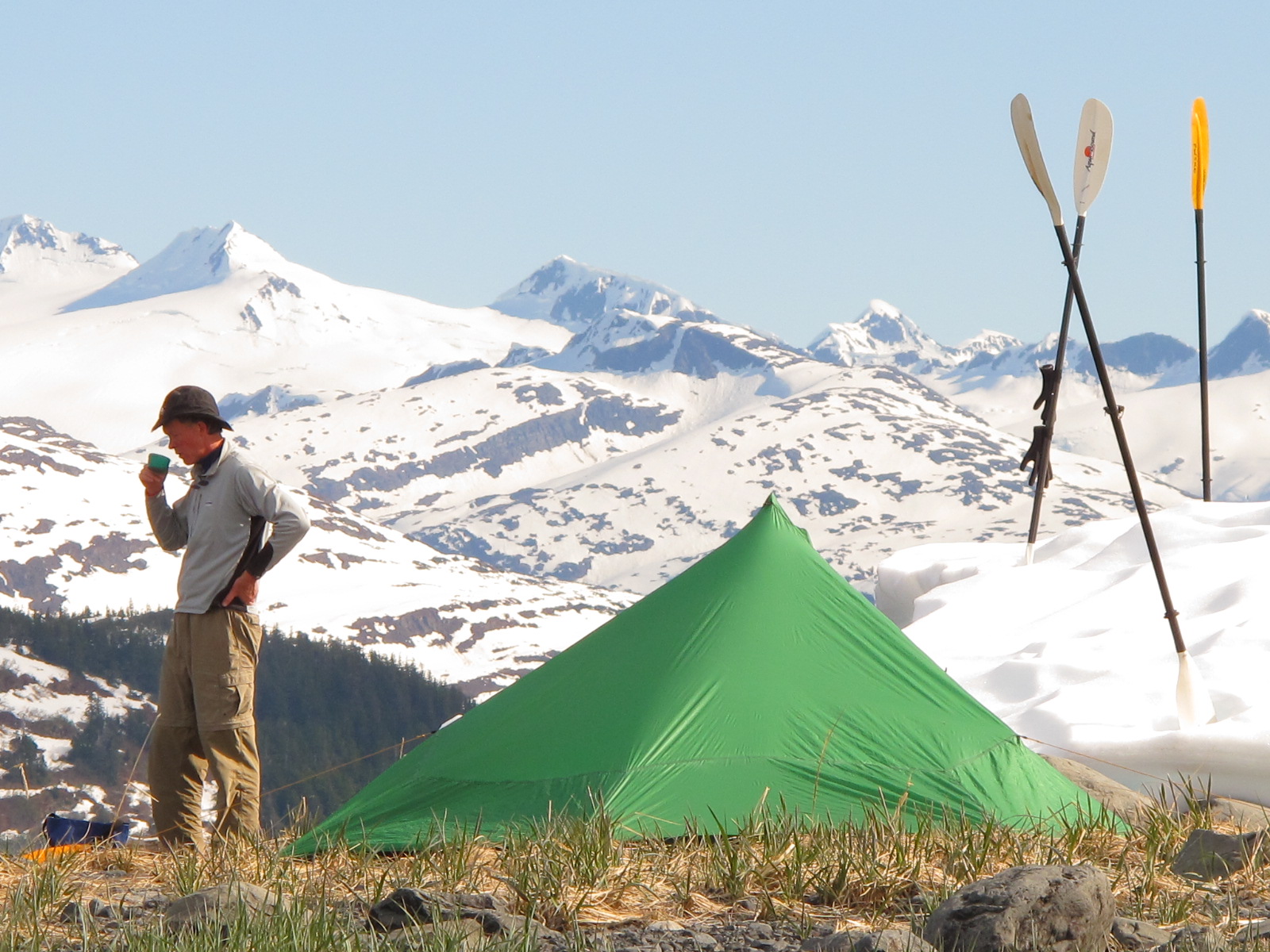
Doug A. enjoys a morning cup of coffee at Camp 1 on the start of the second day.
 
Doug E. kayaking in front of Beloit Glacier.
Self-portrait at Beloit Glacier.
Kayaking among the Beloit bergs.
Doug E. and the waterfall at Blackstone Glacier.
Doug E. reviews the map at Camp 2.
Doug A. cooks dinner at Camp 2.
We woke up the next morning and made breakfast in more beautiful weather.  Afterward we packed the kayaks and watched a black bear high on Lawrence Glacier.   I have no idea what it was doing up there on all the ice and snow.  We shoved off and paddled our way through the glacial bergs that had fallen from the face of Beloit Glacier.  It was fun dodging and turning to miss the bergs that were floating in the water.  It was also neat to hear them because they snapped, crackled, and popped like Rice Krispies.  We enjoyed the company of many curious seals and sea otters.  We found another very small campsite and put up the tents before kayaking over to Blackstone Glacier where we spent the afternoon floating around watching the glacier calve, a giant waterfall, and a bird rookery.  We even got out on a beach and sat in the sun for over an hour watching the spectacle in front of us.  It was perhaps the most beautiful place I have ever been.

Returning to Camp 2 we cooked dinner and was surprised at how quickly the temperature dropped when the sun went behind the mountain.  Soon it was was time for sleep and we made it through the night without any worries about the tide getting us.  The warm sun was back the next morning and as we listened to the weather forecast on the VHF radio we learned it would probably be there for the remainder of our trip.

MILES PADDLED:  5.8

DAY 3
Decision Point State Marine Park signage.
The tent site at Decision Point State Marine Park.  Passage Canal is in the background.
The evening campfire at Decision Point.
We loaded up the kayaks and set out along Willard Island with our destination being Decision Point.  This was to be our longest paddling day mileage-wise.  We stopped at the tip of Willard Island for a snack then scooted over to 13 Mile Beach where we ate lunch and chatted with several other kayakers.  Everyone raved about the weather and excellent kayaking conditions.  From 13 Mile Beach we paddled on the outgoing tide to Decision Point which is a State Marine Park, complete with food storage lockers, wooden walkways, and an outhouse.  It was quite different than our previous two camps.  We unloaded the kayaks, made dinner, watched the boat traffic in Passage Canal, and had the first campfire of the trip.  The weather continued to be perfect and sleep came easy.
MILES PADDLED:  13.8


DAY 4
Kayaking in Passage Canal toward Whittier...and cheeseburgers!

We woke up on the final morning of our trip and made the last breakfast before breaking camp and loading the kayaks.  We were on the water by 10:30 AM, making way to Whittier.  At the beginning the water was flat and the air calm, but when we passed Squirrel Cove the wind picked up and the seas became choppy and confused.  We passed the front of Shotgun Cove and paddled to shore where we could relax for a few minutes and consider our options.  We decided to go around Trinity Point and see if things would calm down.  They didn't.  The waves were big enough that when I looked at the other kayaks I would frequently see both the bow and stern of their boats out of the water the mid section riding the peak of the wave.  We paddled a bit further and pulled into Emerald Cove where we called Epic Charters to see if they would be able to come and get us.  They said that things had begun to settle down in Whittier so we decided to wait a while before calling the paddle short.  We eventually took off and upon rounding the next point we could see Whittier in the distance.  The waters weren't any worse so we went for it.  Before long we were paddling into the Smitty's Beach where we picked up and taken to the truck.

We loaded our gear in the truck and put the kayaks on top.  Then we were off for a celebratory cheeseburger at one of Whittier's eating establishments.  It was the perfect ending to the perfect kayak trip.

MILES PADDLED:  10.1

Saturday, March 23, 2013

HOMER FEEDER KING FISHING TRIP


The GPS track of the boat ride from the Homer Small Boat Harbor to the area where we trolled for salmon.

This is a detailed tracked of ~6 hours of fishing.  We made lots of small circles looking for feeder kings.

Jim is standing aboard the Huntress before leaving the harbor.

Kevin caught the biggest fish of the day.


A view from the flying bridge with Seal Rock in the background.


It was cold at 5:30 AM, when I stopped at Jim's house to pick him up for the drive to Homer where we would board a charter boat and head out in hopes of catching some feeder king salmon.  But, at minus 5 degrees I wasn't looking forward to the ride to the fishing grounds.  My skepticism only worsened as we drove along the spit watching breakers pound the beach.  Jim said, "That looks kind of rough.  I bet the captain will cancel."  Rough seas and cold weather.  You really have to want to catch a fish.

Once aboard the Huntress and in the warmth of the cabin the captain delivered some welcome news.  Since seas were 8-10 feet near Seldovia we wouldn't be heading that direction.  We would go north instead where he hoped the water would be flat, but there might not be as many fish.  He was correct on both counts.

Thirty minutes after leaving the harbor we were fishing.  An hour-and-a-half later we caught the first of two fish for the day.  A group of traveling nurses from Minnesota was also on the boat so we had plenty of company to visit and trade stories with in order to pass the time.  Later in the afternoon, Kevin reeled in the second and final fish of the day.  The temperatures warmed considerably and it was great to be out on deck in the sun trolling the flat water of Kachemak Bay.  Even if the fish were not abundant.

Around 3:30 PM, we reeled in and made the trip back to Homer.  Jim and I stopped for pizza at Fat Olives and then motored home where I arrived in time to watch a recording of the season premier of the Deadliest Catch.  Now those guys can fish in the cold and heavy seas!

Tuesday, March 12, 2013

WATSON LAKE TO SKILAK LAKE SKI

DISTANCE:  5.2 miles
TERRAIN:  Snow covered taiga, lakes/ponds, dense brush, road.
TIME:  ~4 hours

Mrs. Huffy skis across a snow bridge over the East Fork of the Moose River as we begin our trek.  Note the sunburst in the water.

Taking a breather on Marsh Lake in the brilliant sunshine. (photo courtesy Mrs. Huffy)

Mrs. Huffy on Marsh Lake.

Wing marks from a bird of prey.  It clearly caught something in this area as tracks indicating a struggle were all around.

Mrs. Huffy bushwhacking.  This lasted for about a half-mile...which was plenty.

On the road to Lower Skilak Lake Campground/Boat Ramp.

Finally, back at the vehicle.


The ski from Watson Lake to Skilak Lake has been on my list for a long time.  So, after a thorough study of the route on Google Earth and convincing Mrs. Huffy it would be a great trip we took off on a brilliant sunny morning.  This trip requires two cars so we left the Subaru at Lower Skilak Lake Campground, then drove to Watson Lake where we parked the truck.

The first challenge of the trip was crossing the East Fork of the Moose River.  We were in luck because there were still plenty of snow bridges to choose from and we crossed with ease.  Then it was on to Marsh Lake which was flat and easy.  Once across the lake things became more interesting.  There was lots of overflow in the lake drainage which was covered by snow.  Our feet got wet.  Then we entered an area of extemely dense brush and downed trees.  After a half-mile or so we popped out on Skilak Loop Road which we skied the remainder of the way to our car.

Along the way we spotted some evidence of animals including a beaver dam, the imprints of bird wings in the snow, one set of moose tracks, a couple of snowshoe hare trails, and the prints of a coyote.  We did see an American Dipper as we were crossing the snow bridges, but not much beyond that in terms of live critters.

Overall, it was a great trip made even better by the warmth of the sun.  But, I don't think it will become a regular ski due to the shuttling of cars and the bushwhacking, although that makes it memorable...in my book.

Monday, December 31, 2012

...Sheep Mountain Lodge

The track of our drive from Nikiski to Sheep Mountain Lodge.

The tracks of a couple of our ski outings.

The sign near the highway.

Mrs. Huffy and Emily near the main lodge building.

Mrs. Huffy poses during a ski outing.

Laura skis through the surrounding mountains.

The Hufford girls ski the trails.

Mrs. Huffy and Emily on the front deck of our cabin.

Monopoly tournaments were played for several hours each evening.

Mrs. Huffy and Laura skiing the Serpentine Trail.

Mrs. Huffy used her headlamp to ski at night.
Emily enjoys some reading time before going to bed.


This past summer as we drove out of Alaska on our big trip we passed Sheep Mountain Lodge.  We made a note of it and decided to return during the Holiday break to take in the beauty of the area and do some skiing on their 20 kilometers of groomed trails.  It was a great decision.

Sheep Mountain Lodge is semi-remote.  You can drive to it but it's a long way from much of anything, which makes it compelling.  The lodge itself was built in 1946 and is a classic example of an Alaskan roadhouse.  The cabin we stayed in is newly built and has all the amenities of home.   We cooked and ate all our meals using the fully stocked cabin kitchen and dining area.  Cell phone service is iffy, but the main lodge has wireless internet which we didn't feel the need to use.  In fact, it was nice to be away from cell phones and internet for a while.  It was even better to be away from television.

We spent the days skiing and using the hot tub.  Then, after dinner, we would conduct some serious Monopoly tournaments.  Emily would generally buy every property she landed on and we would all think she was about to go bankrupt.  About that time she would mortgage said properties, pass go, collect $200, buy houses and hotels, and ultimately wipe us out with exorbitant rents on places she owned...like Boardwalk.  Yes, it was humbling.  Never underestimate the financial wizardry of a 4th grader.

So, it really was very perfect.  Remoteness, skiing, Monopoly, food, the Hufford girls.  Things couldn't have been better.  All at a beautiful place known as...Sheep Mountain Lodge.

Monday, December 24, 2012

...Global Fatbike Day

THE ROUTE:  Start at Stormy Lake boat ramp/ride across Stormy Lake to swim beach/push bike up to Kenai Spur Highway/ride highway back to Stormy Lake boat ramp.

About to ride across Stormy Lake.  (photo courtesy of Mrs. Huffy)

Mrs. Huffy was on her skis for part of the adventure.

The fatbike takes a break while crossing stormy Lake.

Pedaling across Stormy Lake.  (photo courtesy of Mrs. Huffy)

The official declaration.

When I heard there was going to be an official Global Fatbike Day, I knew I would have to come up with plans for a unique adventure.  Since one of my favorite nearby outdoor places is Stormy Lake, I quickly hatched the idea of riding a loop which included: crossing the lake/riding up the road that goes to the swim beach/then pedaling back down the Kenai Spur Highway to the boat ramp.

The weather was beautiful, albeit cold, when I started across the ice.  It really didn't take long (about 40 minutes) before I was at the swim beach stairs where I shouldered the fatbike and carried it up to the parking lot.  I tried riding up the road but the snow was too deep so I pushed the bike to the highway.  From there it was a pleasant cruise to the boat ramp.

And, that was it.  Mrs. Huffy and I loaded our gear back into the truck and drove home.  On our way we were already making plans for the next...Global Fatbike Day.